
ESTEIO ENGENHARIA E AEROLEVANTAMENTOS S.A. was founded in 1969 as a privately held Brazilian company. Acting as a consultancy company, ESTEIO’s activities are mainly concentrated on the development of projects, services and researches in the area of civil and cartographic engineering.
In 1979, ESTEIO was officially recognized by Brazilian Ministry of Defense as “A” category company capable of all cartographic portfolios from aerial images to final printed maps. In 1995, ESTEIO acquired its first orthophoto analytical processing system and nowadays incorporates global state-of-art photogrammetric equipments for this purpose. Flying with its own fleet of aircrafts, ESTEIO began a new era in 2001 as a pioneer of using LiDAR systems for LASER Scanning such as ALTM 2025 equipment from Canadian company Optech. In 2006, ESTEIO was the first Brazilian company to use the family of aerial large format digital sensors with pushbroom technology formed by ADS 40/52, 80 and 100.

At the same time, ESTEIO also performed LiDAR surveys with the newest Hexagon-Leica ALS50-II MPiA LiDAR systems. More recently, in 2020, ESTEIO acquire the first hybrid sensor of Latin America, a Hexagon-Leica CityMapper H2 equipment combining nadiral & oblique aerial medium format digital camera and LiDAR sensor with 2MHz of operation frequency.
This pioneering spirit brought ESTEIO recognition as one of the largest companies in the country in aerial surveying and cartographic production.
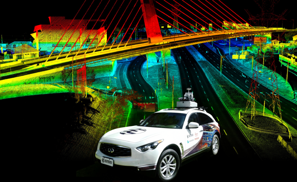
ESTEIO also operates its own Mobile mapping System (MMS) for collecting geospatial data with Highways inventory and asset management purposes and Digital Twins applications for urban environment.
In the area of geotechnical prospecting, ESTEIO works with non-invasive investigation technologies such as PCM (Pipeline Current Mapping) for locating and verify the integrity of pipelines, GPR (Ground Penetrating Radar) for subsoil stratigraphy and investigation, SBP (Sub Bottom
Profilers) for subsoil investigation in submerged areas, DCVG (Direct Current Voltage Gradient) to locate and investigate buried structures and Multibeam Echosounder equipment to developing bathymetry services on shallow waters.
ESTEIO has an engineering division responsible for developing geometric designs for highways, railways, airports and FEED (Front End Engineering Design) for pipelines. The company is also capable of monitoring and managing highways construction and operating special highway scales to control heavy traffic that damages the pavement.
ESTEIO is also associated with the company VER RODOVIAS Ltda. and with the company ETT – ESTEIO Tecnologia em Trânsito Ltda., exploring maintenance management technology on roads and urban environments, including the installation and operation of speed radar systems on highways and urban roads, operation of its own special vehicles with integrated sensors to evaluate and measure road geometry and pavement integrity, developing of software for traffic analysis, traffic control and automated road panels.
Our company ESTEIO ENGENHARIA E AEROLEVANTAMENTOS S.A. was born in Curitiba and evolves with our beloved city. In more than 50-years of existence and innovations, it remains committed to fully meeting the quality, safety and environmental requirements to its customers, seeking excellence in the performance of all services.” — Carlos Valério Avais da Rocha, President and CEO